Giro d’Italia 2023: маршрут и альтиметрия всех этапов
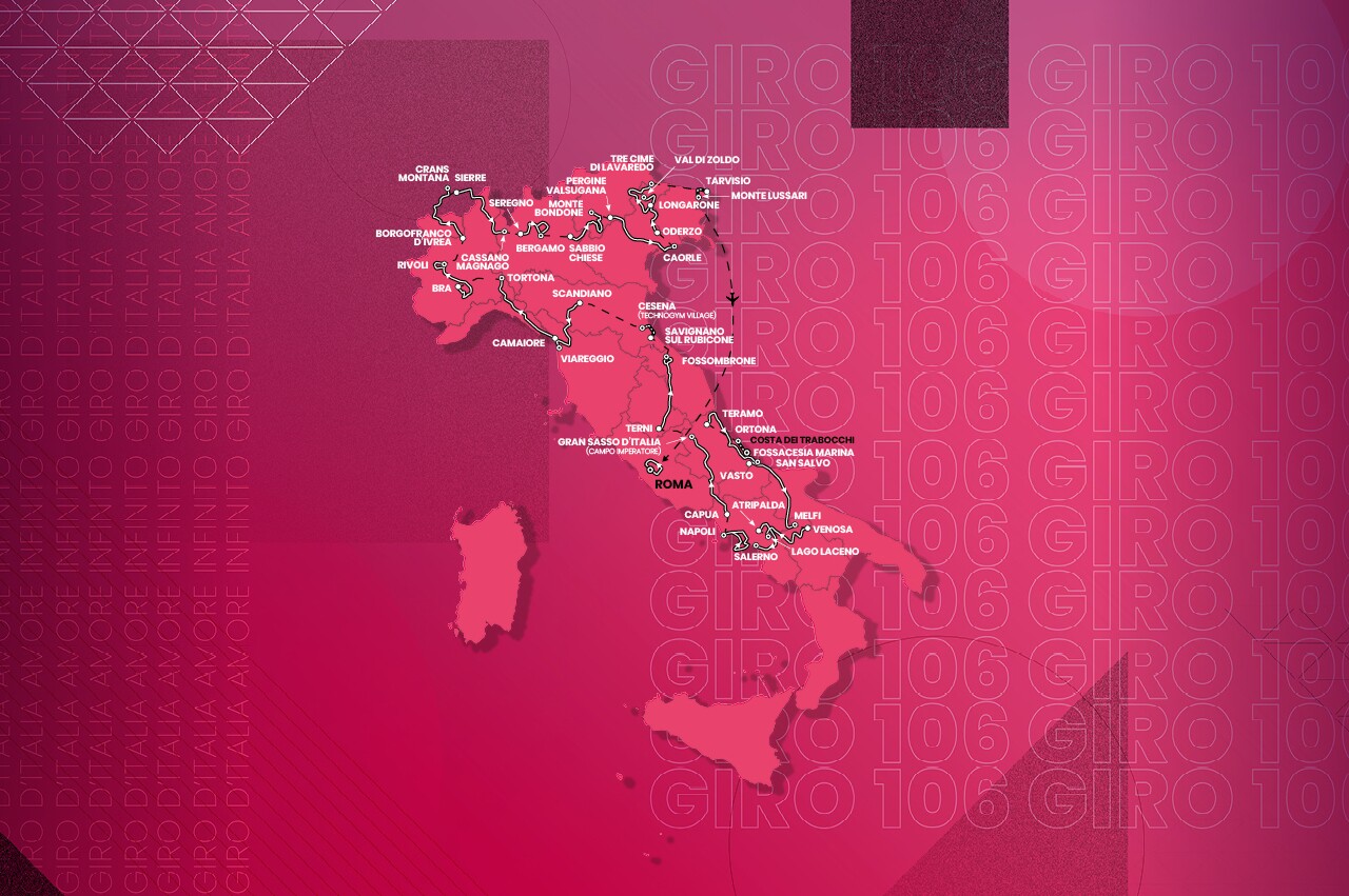
The 106th Giro will start on Saturday, May 6 , with an individual time trial through the Abruzzo region and will end on Sunday, May 28, with a flat stage around the center of Rome.
Over three weeks, the peloton will tackle five real mountain stages, five hilly days, eight flatter stages and three individual time trials.
The first week begins and ends with time trials and will take the Giro peloton along a flat route along the Adriatic coast towards Basilicata, through the Monte Vulture massif, to the descent to Rapolla and then the climb to Melfi.
Stage 7 towards Campo Imperatore will set the stage for the first serious mountain finish. The Gran Sasso d'Italia has only appeared six times, with Adam Yates winning the last ride to its dizzying heights in 2018.
The sprinters and favorites to advance from the group in week two will be pleased. But after two flat days, the route heads into Switzerland and the brutal western Alps. It is here that the peloton will encounter Cima Coppi, the highest point of the Giro – Colle del Gran San Bernardo, reaching 2469m.
As usual, there will be no rest in the final week. Starting with the mountainous distance of stage 16, heading towards Monte Bondone, which offers more than 5,000 meters of vertical ascent.
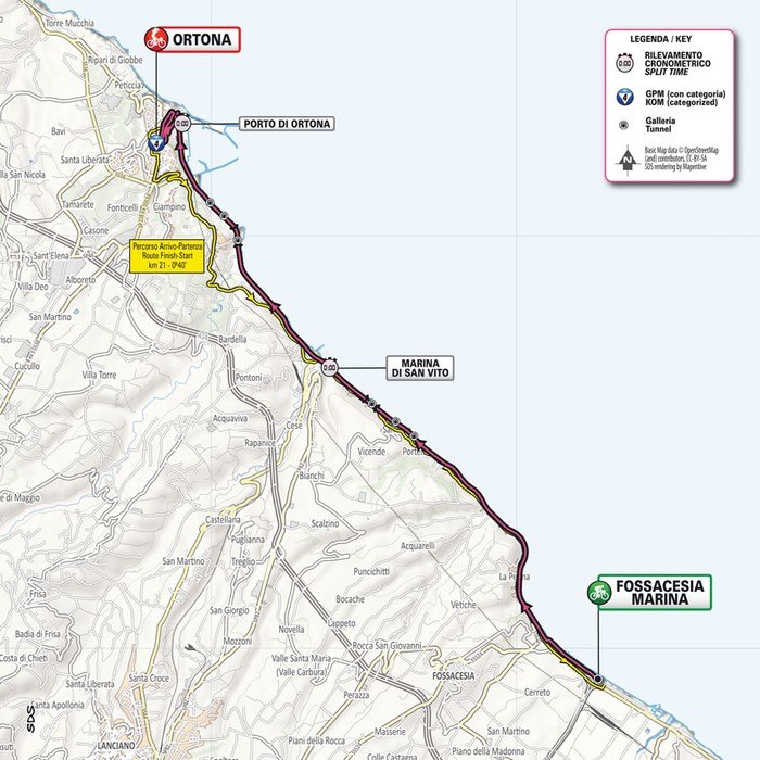
Stage 1: FOSSACESIA – ORTONA 18.4 km.
Saturday, May 6
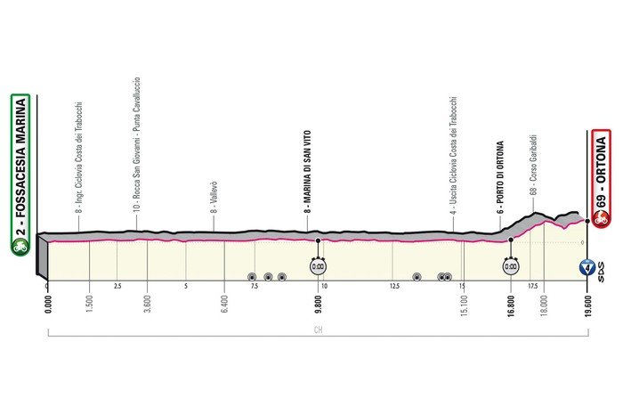
The route runs almost entirely along the Via Verde along the Adriatic Sea, an old railway line that has been restored and converted into a cycle path. It is part of the Ciclovia Adriatica, a route that starts in Trieste and runs along the Adriatic coast, ending in the deep south of Italy in Puglia. Its total length is more than 1,300 kilometers.
The Via Verdes, like the ITT route on the first day of the Giro, is mostly flat. Cyclists ride along the coast from Fossacesia Marina to Ortona and leave the track for a sharp finish. The last 1.2 kilometers are a 5.3% climb to the local Aragonese Castle, perched on a cliff overlooking the sea.
There are two intermediate time controls along the way - at 10.5 kilometers and at 15.8 kilometers.
Last year's Giro featured a similar time trial on day two, although it was half as long, with Simon Yates winning ahead of Mathieu van der Poel and Tom Dumoulin.
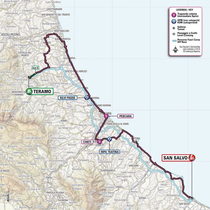
Stage 2: TERAMO - SAN SALVO 204 km
Sunday, May 7th
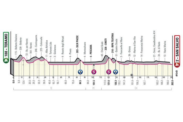
The stage starts with a slight descent, followed by a 5.4-kilometre climb with a 4.4% gradient. Up to the 40th kilometre, the route climbs and descends with slight inclines, and then runs on a flat road for almost an hour.
After 80 kilometres there is a 4.2 kilometre climb with a 5.4% gradient to Silvi, and after another hour on a flat road the last hills follow. First there is a 4.5 kilometre climb with a 6.2% gradient to Chieti, and the last obstacle of the day is in Ripa Tetina - 2.6 kilometres with a 5.2% gradient.
The route returns to the coast at Ortona, where there are more than 70 kilometres to go before the finish at San Salvo, south along the Adriatic Sea.
The second stage is largely on the same roads as the seventh stage of the 2021 Giro. That race ended in Termoli, where Caleb Ewan took a comfortable sprint victory.
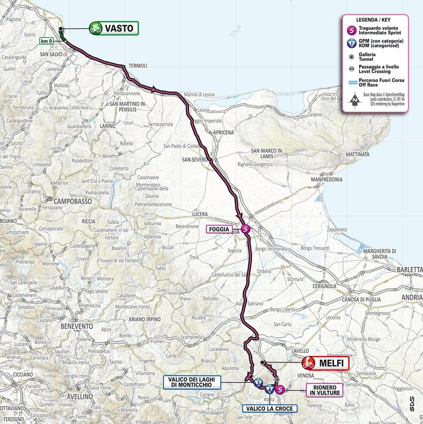
Stage 3: VASTO – MELFI 200 km
Monday, May 8
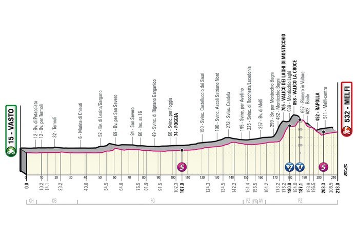
The third stage of the Giro is likely to end in Melfi. The route is over 200 kilometres and runs through flat and hilly terrain to the town at the foot of Monte Griffe, an extinct volcano.
Riders set off from Vasto, which sits high above the sandy beaches of the Adriatic coast. Three years ago, a stage of the Giro was held there. The race led to L'Aquila, where Pello Bilbao won from a long way in a thrilling finale.
This year, Stage 3 sets off from the Abruzzo region and heads south. Riders will face a day of hilly terrain, although strong sprinters may find success in Melfi. The route stays close to the coastline in the first part before turning inland in the second.
The last Giro finish in Melfi was in 1994, when Italian rider Endrio Leoni won the mostly flat stage.
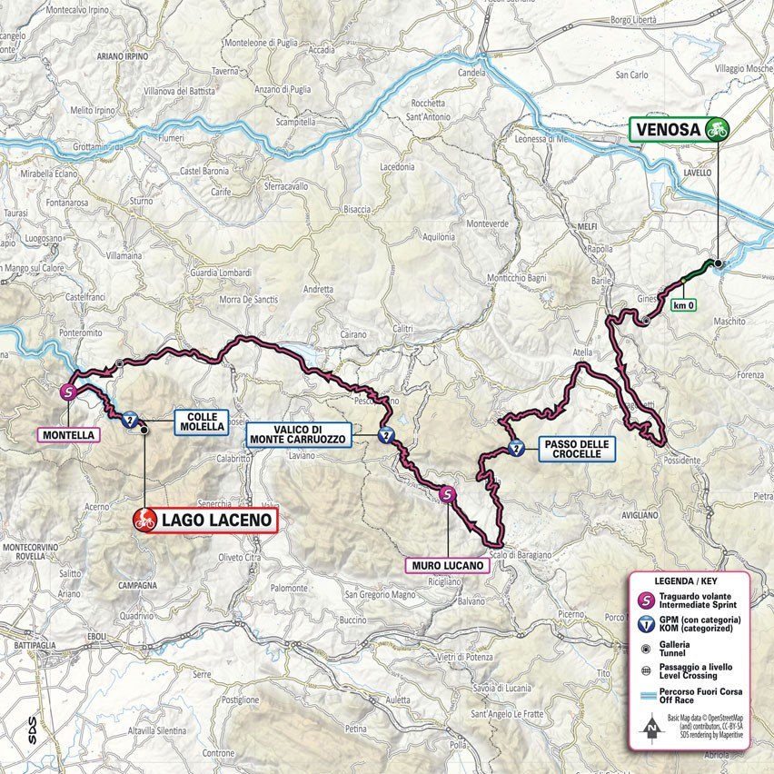
Stage 4: VENOSA - LAGO LACENO. 184 km
Tuesday, May 9
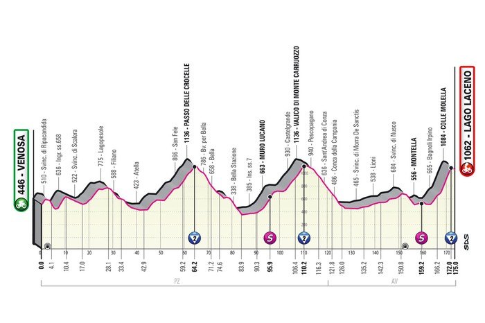
This day should create an advantage between the contenders for the overall victory. The finish line is located in the Lago Laceno ski resort, 3.5 kilometers from the 8.4-kilometer Colle Molella. So it’s not exactly a mountaintop finish, but it’s still expected to be a great start for mountain bikers.
This is the fourth time the Tour of Italy has finished on Lago Laceno, the last time being in 2012, when Domenico Pozzivivo won solo.
Colle Molella is 8.4 kilometres long, with a climb of almost 7%. It is an uneven climb with several kilometres of double-digit gradient, while other sections are simply flat. The maximum gradient is 12%.
Once at the summit, the route continues for another 4.4 kilometres over rough terrain to the finish line at Lago Laceno.
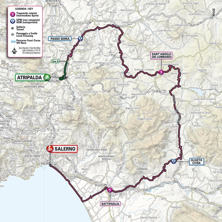
Stage 5: ATRIPALDA – SALERNO. 172 km
Wednesday, May 10
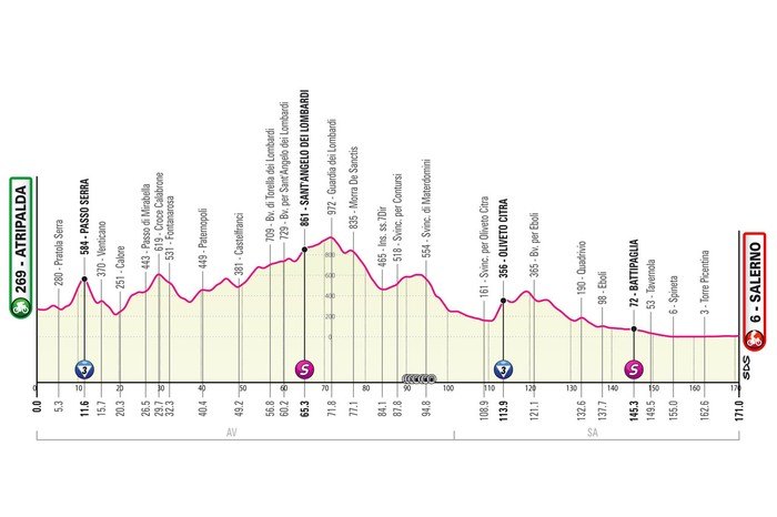
Stage 5 of the Giro starts in Atripalda and ends in Salerno. The race is 172 kilometers long and climbs 2,400 meters.
The route starts with a climb. After a flat section of 7 kilometers, the riders begin the climb to Passo Serra - 6.2 kilometers long with an average gradient of 4.8%. This sets the tone for the race. The first half of the race is up and down until reaching the highest point at Guardia dei Lombardi. This is an 8.4-kilometer climb with a gradient of 3%, and the summit reaches 977 meters above sea level. The summit is reached with still 100 kilometers to go.
The route descends with short breaks to the Oliveto Citra ravine, where the steepest climb of the day appears: 2.6 kilometers with a gradient of 8%. The last 50 kilometers go down to the Mediterranean or along the flat coast to the likely sprint finish line in Salerno.
Salerno has already been the finish of stages of the Giro ten times, although that was a long time ago. In 1995, Rolf Sorensen won in this city at the start of the stunning Amalfi Coast.
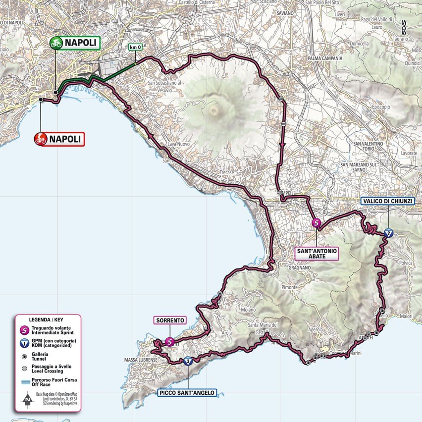
Stage 6: NAPLES – NAPLES. 156 km
Thursday, May 11
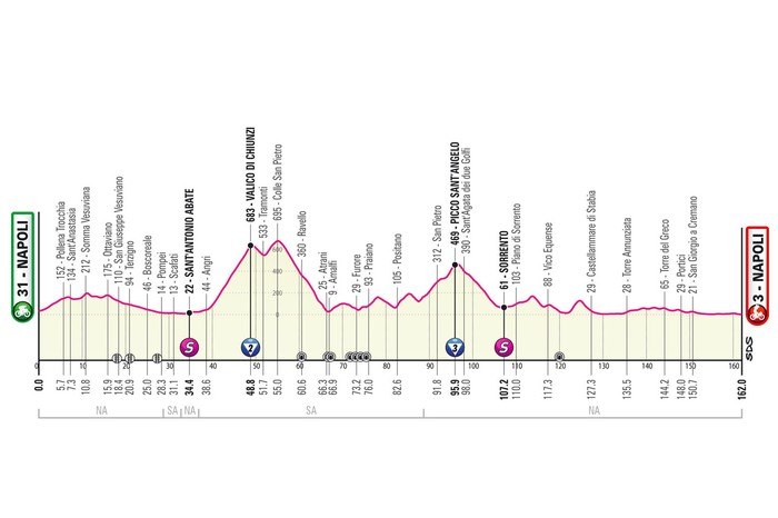
The sixth stage of the Giro takes place in Naples. The route is 156 kilometers long and has 2,800 vertical meters. Most of the climbs are in the first 100 kilometers.
Gentle climbs, slight descents - this is the route for the first 20 kilometers. Then the riders will pass through Pompeii and continue to the foot of Valico di Chiunzi, a 9.8-kilometer climb with a 6.1% gradient. After receiving points, the route continues to climb slightly until the descent begins at 54 kilometers.
Riders reach the Mediterranean at Amalfi and continue along the coast in a northerly direction. Before Positano, the route returns to the climbs and runs to the peninsula bordering the southern part of the Gulf of Naples. The Capo di Mondo route is therefore 14.7 kilometers long, but the gradients are very slight. The hardest part is the last 5 kilometers, and here the gradient is only 4.2%.
The riders descend the technical descent into Sorrento to head back towards Naples. The last 60 kilometres are flat.
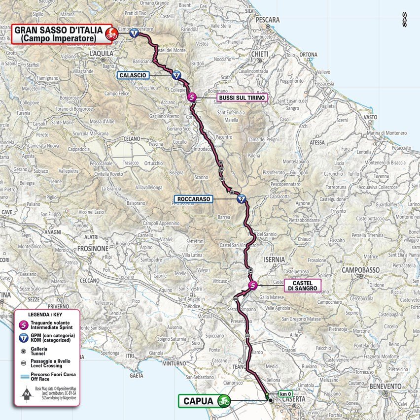
Stage 7: CAPUA - GRAN SASSO 218 km
Friday, May 12
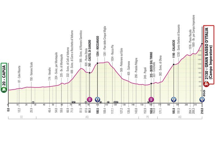
The race through the Apennines includes three intermediate climbs, and the last 50 kilometers are almost entirely uphill. The total length of the route is 218 kilometers, making it one of the two longest stages of the entire Giro.
The mountain's full name is Gran Sasso d'Italia, which is appropriate since it means Great Stone of Italy. Gran Sasso is dominated by three peaks: Corno Grande, Corno Piccolo and Pizzo Intermesoli. At 2,912 metres, Corno Grande is the highest peak in the Apennines.
Cyclists don't climb as high, but finishing at 2,135 metres above sea level is still impressive. At this altitude, oxygen availability is 5% lower.
The route starts to climb after a flat section of almost 70 kilometers. Rionero Sannitico is a 14-kilometer climb with an average gradient of 4.6%. After a short descent and a flat section, the next climb is to Roccaraso. It is an 8.9-kilometer climb with a gradient of 6.2% and the steepest climb is 12%.
After crossing Roccaraso, the route continues on a flat section for 10 kilometers, after which a long, drawn-out descent begins to the foot of the Calascio climb. At 13.7 kilometers, this climb averages 6%. Above the almost abandoned village rises Rocca Calascio, an impressive mountaintop fortress at 1,460 meters.
The final climb begins at the foot of the Calascio climb, 47 kilometres away. After passing through the village, the route remains flat for 5.6 kilometres before climbing again. At this point, cyclists are on the final climb to the Campo Imperatore – or Imperial Field – of the Gran Sasso. This is the largest plateau of the Apennine range.
In fact, the final climb of stage 7 starts with 10 kilometers at 4%, after which there is a flat 9 kilometers, followed by 3 kilometers at 4.1%. Then the Gran Sasso starts to show its teeth. The last 4.5 kilometers to Campo Imperatore are at 8.2%, and the steepest climb of 13% appears 1.5 kilometers before the finish.
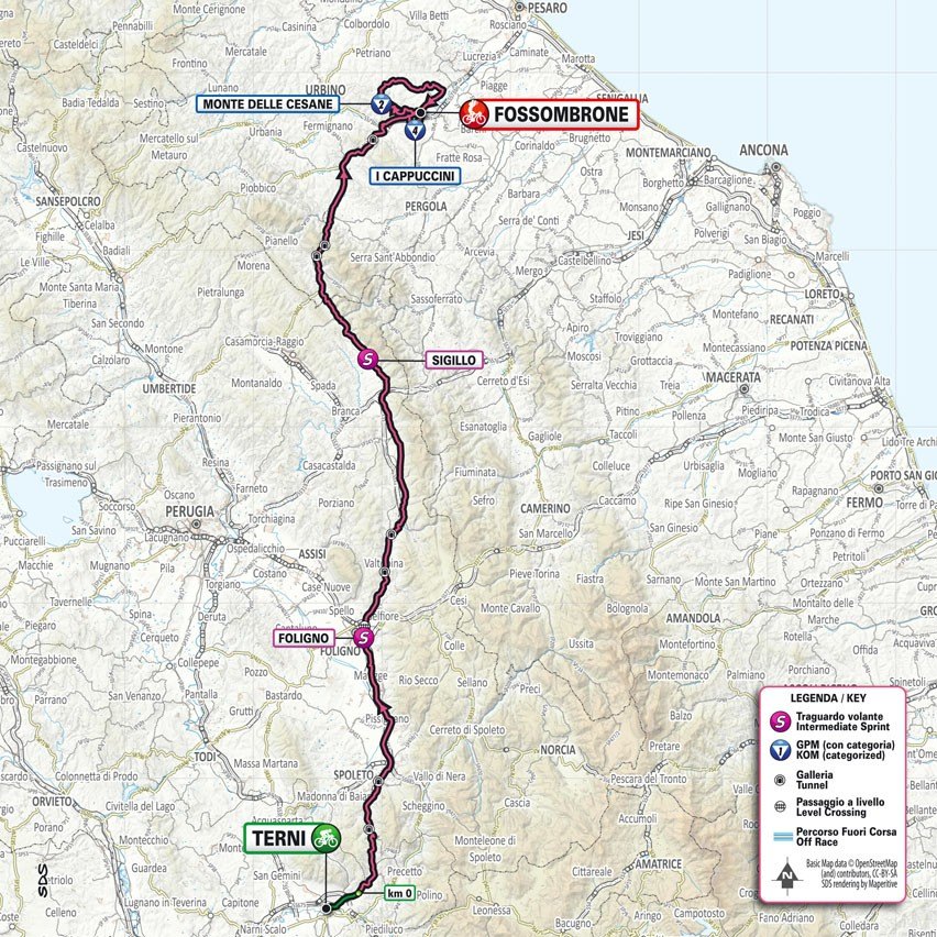
Stage 8: TERNI – FOSSOMBRONE 205 km
Saturday, May 13
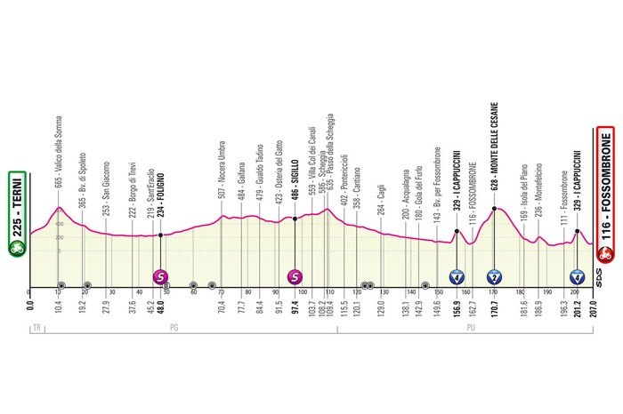
The 205km route between Terni and Fossombrone includes two intermediate climbs, then a challenging final section that includes a double climb over the Muro dei Cappuccini and Monte delle Cesane, before ending with a descent.
Alexey Lutsenko showed himself in a similar finish line at stage four of the 2019 Tirreno-Adriatico. The Kazakh attacked from the leading group entering the final section. He fell several times before Primoz Roglic, Adam Yates and Jakob Fuglsang caught him in the last 700 meters. Lutsenko did not panic. Instead, he stood tall and passed the three at the finish.
Let's hope for such a dramatic race at the Giro as well.
The route allows for such an outcome. Right from the start, riders must negotiate the climb to Valico della Somma – 4.5 kilometres at 6.5% – before entering a hilly section. The Passo della Scheggia – 3.5 kilometres at 3.2% – appears about halfway, after which a long descent leads to the first climb above Muro dei Cappuccini. It’s 2.1 kilometres long at 10%, but with 50 kilometres still to go, it’s little more than an obstacle.
The Giro descends to the base of Monte delle Cesane. This climb is 7.2 kilometers long with an average gradient of 7.1%. A short climb follows the descent, and after almost 10 kilometers the riders climb again to the Muro dei Cappuccini.
The descent is almost 5 kilometers long and technical, and the finish line is flat.
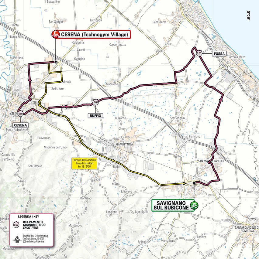
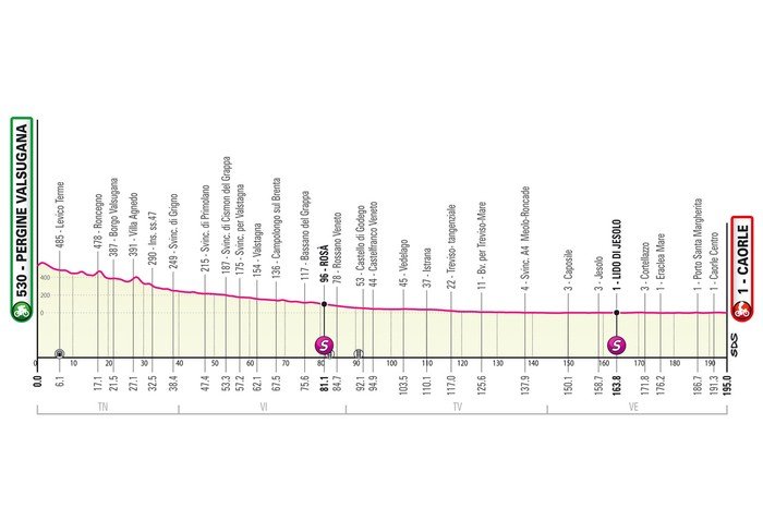
Stage 9: SAVIGNANO SUL RUBICONE – CESENA 33.6 km
Sunday, May 14
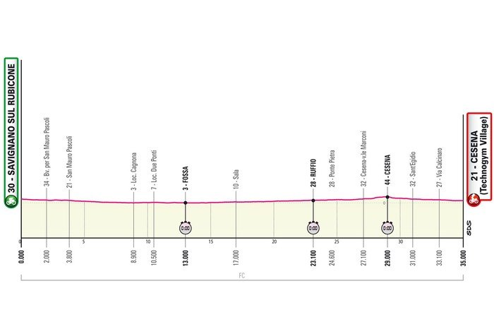
The ninth day of the Giro features the second of three sprints. Over 30.7 kilometres, riders will race along straight and flat roads from Savignano sul Rubicone to Cesena.
The longest and flattest of the three time trials of the Italian Grand Tour, the route is favoured by sprinters.
There are two intermediate time controls – at 9,800m and at 20,300m.
The total number of kilometres timed at this Giro is over 70 kilometres, unprecedented in recent Grand Tours, prompting world champion Remco Evenepoel to become the first GC rider to confirm his participation in the 2023 Giro d'Italia.
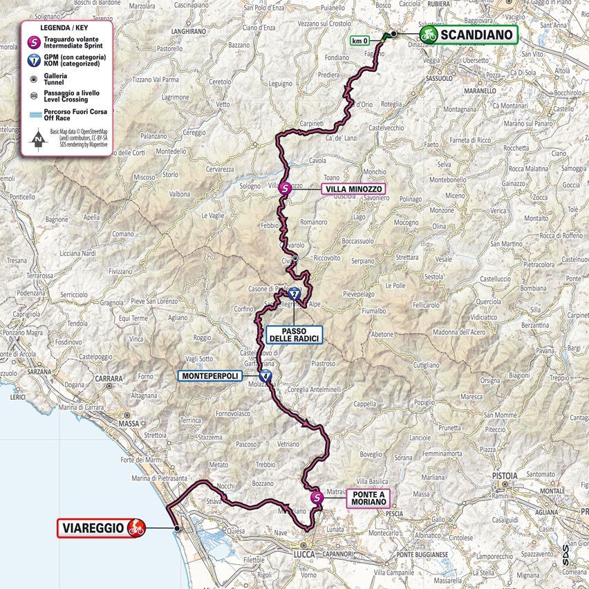
Stage 10: SCANDIANO – VIAREGGIO. 190 km
Tuesday, May 16

The riders leave from Scandiano to Viareggio for stage 10 of the Giro. The route is 190 kilometers long and the climb is approximately 2,400 meters. Since most of the climbing takes place in the first half of the race, we can expect a battle of finishers in Viareggio.
The route starts with an ascent, although the gradient is very pleasant. The first 20 kilometers are slightly uphill, then there is a real climb to La Svolta: 3 kilometers with a gradient of almost 7%.
After the descent, riders enter a very long climb, but again the gradients are very gentle. However, the route climbs for 40 kilometers or so. After passing through Piandelagotti, the Passo delle Radici begins its ascent, which is a real climb: 4.3 kilometers with a gradient of 5.8%. The Passo delle Radici summit is at 1,521 meters above sea level.
There are still 110 kilometres to go at the Passo delle Radici. The Giro descends to Castelnuovo di Garfagnana and then climbs to Monterperpoli, a short 2.6 kilometres but steep 8% climb. The rest of the route is gentle, with about 75 kilometres of gentle descent to the finish in Viareggio.
The Giro has finished eight times in Viareggio, but that was a long time ago. In 1982, Giuseppe Saronni won the first pink jersey in that edition in Viareggio.
Stage 11: CAMAIORE – TORTONA 218 km
Wednesday, May 17
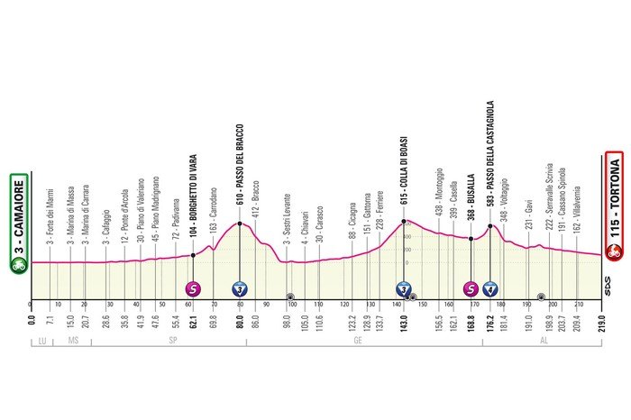
Stage 11 is the longest of the Giro, but not the toughest. The 218 kilometres take riders from Camaiore to a likely road race through the streets of Tortona.
The route goes north along the shores of the Mediterranean to enter Liguria. The maps show three moderate climbs.
The Bracco Pass is reached at kilometre 79.3 after almost 10 kilometres of climbing at a gradient of 4.6%. Riders descend to Sestri Levante to continue on flat ground north. After leaving the coast, the road begins to climb, and will continue to do so for almost 20 kilometres. This is the Colla di Boasi, an endless climb with a gentle gradient of 2.8% on average.
The final obstacle of the day is the Passo della Castagnola, where the Giro leaves Liguria. The 4.9-kilometre climb at a 4.5% gradient is reached with 40 kilometres to go. The first part is downhill, while the last 30 kilometres are straight and flat until the finish in Tortona.
This will be the fourth Giro stage finish in Tortona. The last winner was Fernando Gaviria. The Colombian beat Sam Bennett and Jasper Stuyven in 2017. Having won four stages, this Giro was the highlight of Gaviria's career.
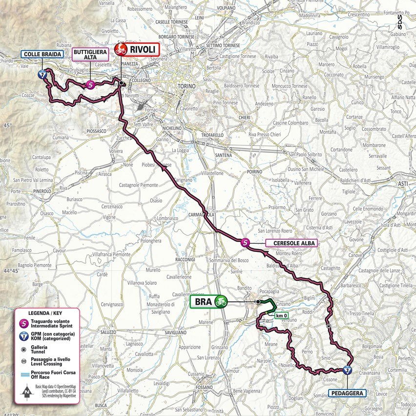
Stage 12: BRA – RIVOLI 179 km
Thursday, May 18
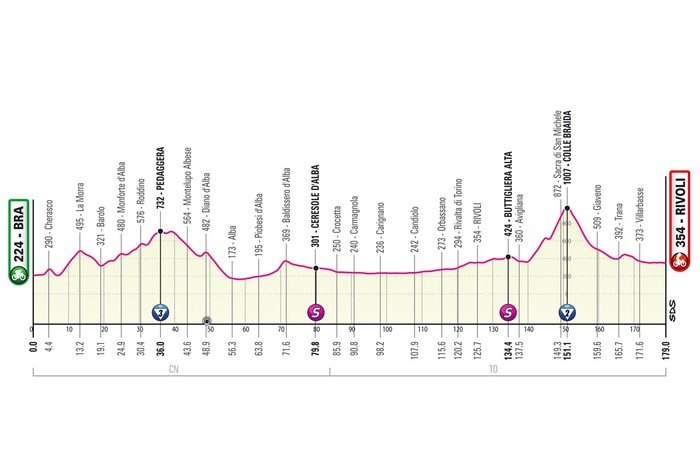
The route from Bra to Rivoli is 179 kilometers. Most of it is on flat roads, except for the first 50 kilometers and Colle Braida in the last 30 kilometers. Braida will probably be an opportunity for the sprinters to conserve energy, opening the way for a successful breakaway.
Other riders expected to conserve energy are the overall contenders. After all, stage 12 includes two massive climbs, ending in the ski resort of Crans-Montana. With more than 5,000 metres of climbing, this is the place to break away from your rivals for the pink jersey.
The same cannot be said for the roads between Bra and Rivoli. The route starts on difficult terrain with a series of short climbs – to Cherasco (1.1 kilometers at 6.2%), La Morra (6 kilometers at 5%), Monforte d'Alba (2.1 kilometers at 4.8%) and Pedagera (4.1 kilometers at 4.3%) – all within the first hour of the race. Riders continue on their way to the final lap around Rivoli.
After passing the finish line with 60 kilometers remaining, riders head to Avigliana to enter Colle Braida. From bottom to top, the climb is 10.8 kilometers at 5.9%, but this statistic is skewed by the descent. The last 5 kilometers climb 8.3% to the top.
A 15km descent takes riders to Reano, where a 1.7km section at 3.3% grade precedes the final 10km on flat road.
Stage 13: BORGOFRANCO D'IVREA - CRANS-MONTANA 208 km
Friday, May 19
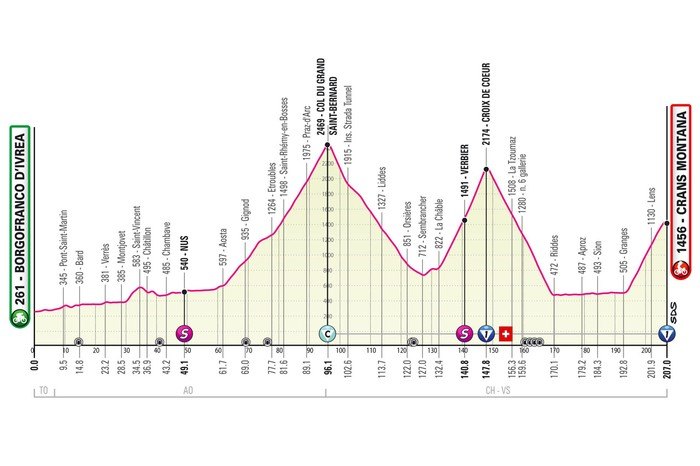
Stage 13 of the Giro d'Italia runs 208 kilometres from Borgofranco d'Ivrea to Crans-Montana, Switzerland. Riders enter Switzerland via the 35-kilometre Colle del Gran Bernardo. It also includes the brutal Croix de Coeur climb, with a 16-kilometre finish.
The last time Crans-Montana hosted the final stage of a major cycling event was ten years ago. Bauke Mollema won the Tour de Suisse. The Dutchman finished half a minute ahead of a group that included Thibaut Pinot and the late Michele Scarponi.
The route from Borgofranco d'Ivrea to Crans-Montana is fairly straightforward. Riders cross the Po plain heading north. The only obstacle is a 3.5-kilometre climb of 5% to Saint-Vincent. The route then turns west and heads to Aosta, where the endless climb to Colle del Gran San Bernardo begins.
The Gran San Bernardo Pass reaches a summit of 2,469 metres. The climb is 34.2 kilometres, with an average gradient of 5.5%. An equally long descent takes riders back to the foot of the Croix de Coeur, which is another giant: 20.8 kilometres long, with an average gradient of 7%. The gradients here are even more daunting, as the first 5 kilometres are not significant. The last 5 kilometres, on the other hand, climb 10.1%.
The route descends to Riddes and after 24 kilometres on flat terrain the final climb begins. The climb to the Crans-Montana ski resort is 15.9 kilometres long and has an average gradient of 7.2%.
Colle del Gran San Bernardo will be the Cima Coppi (highest point) of the 2023 Giro d'Italia.
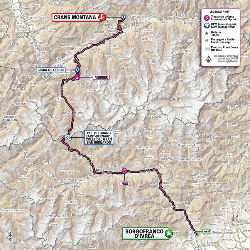
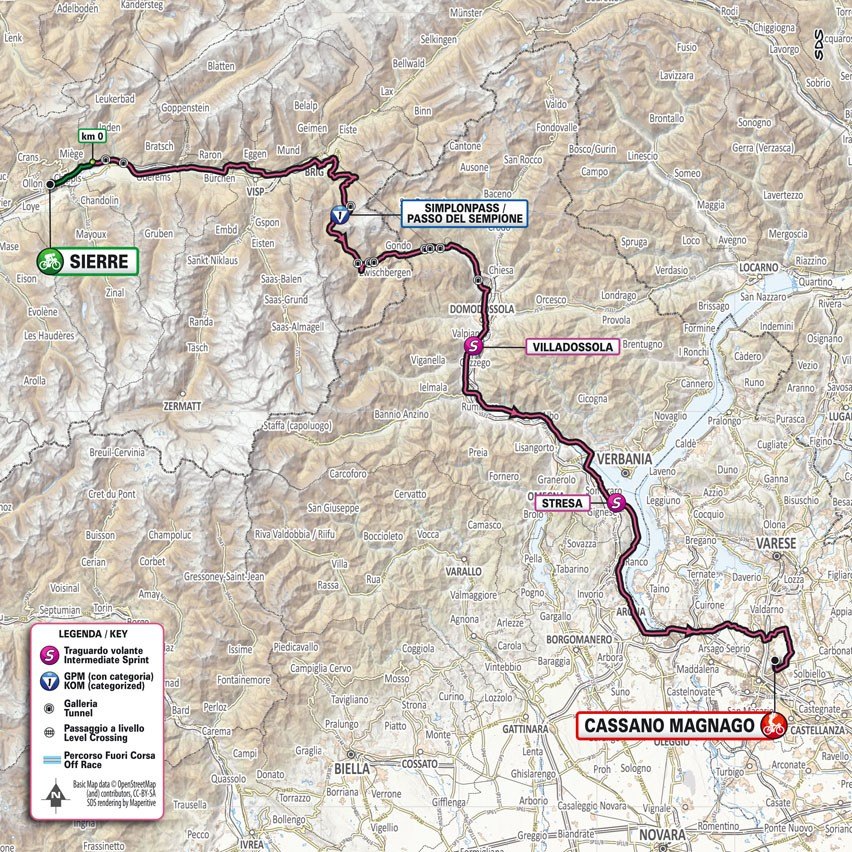
Stage 14: SIERRE - CASSANO MAGNAGO 194 km
Saturday, May 20
This is a typical sprinter's stage, although the Simplon Pass doesn't fit the profile at all. 19.9 kilometers at 6.6% seems completely out of place. Some minor obstacles here and there, but the route is a sprinter's dream. If it weren't for the obstacle that appears after 35 kilometers: the Simplon Pass.
After the descent from the pass, the riders still have 120 kilometers of flat terrain to go. There is one small climb to Quinzano San Pietro - 1 kilometer at 6.1%, with 16 kilometers to the finish - and a flat last 10 kilometers, but that's it. So if the sprinters catch the peloton after the Simplon Pass, there is nothing to stop them from having a finisher's contest in Cassano Magnago.
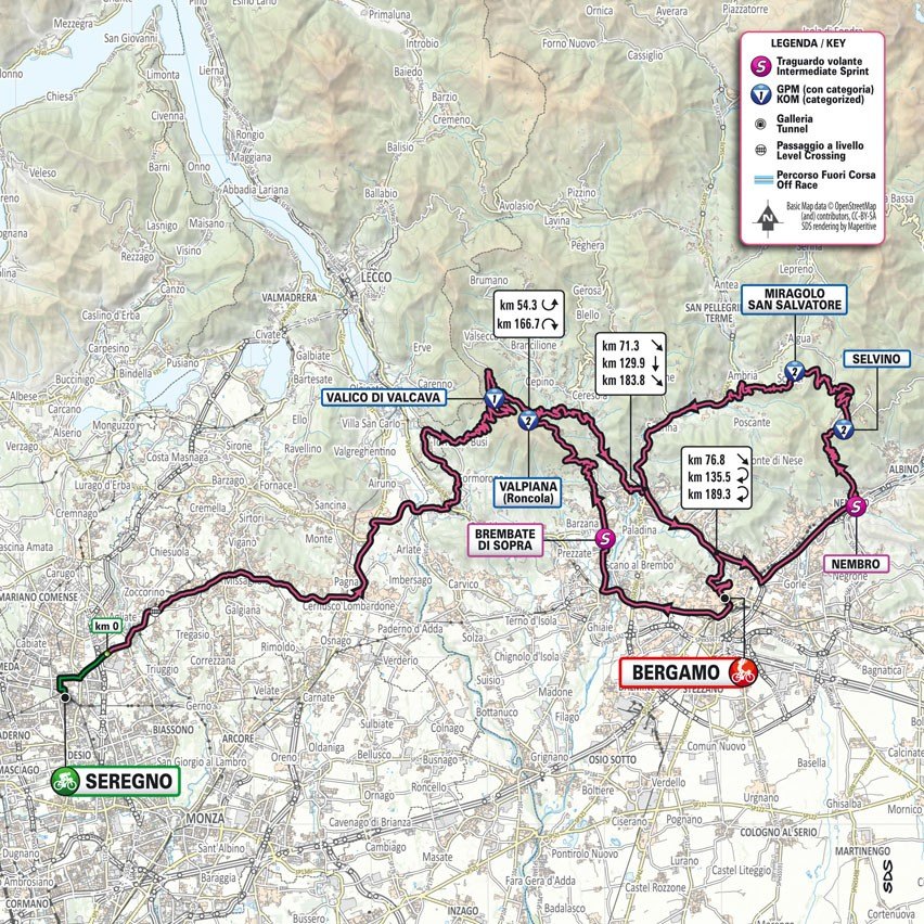
Stage 15: SEREGNO - BERGAMO 191 km
Sunday, May 21st
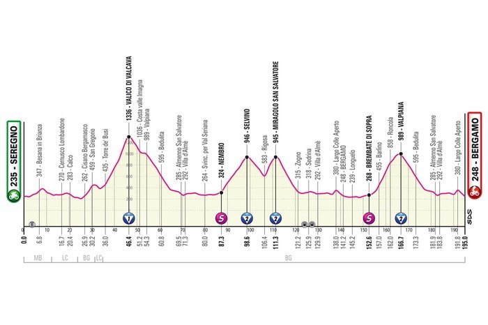
The race starts on slightly hilly terrain, and after 35 kilometers the Valkava Pass appears. An 11.7-kilometer climb rises to the highest point of the route at 1,336 meters. The average gradient is 8%, and the steepest sector at 17% is 7.5 kilometers from the start of the climb, after which the slope does not drop below 10% for 3 kilometers straight.
A long descent and 20 kilometres of flat ground precede the climb to Selvino, a village north-east of Bergamo. The climb is 6.9 kilometres long and has an average gradient of 5.4%.
The riders pass through Bergamo for the first time with almost 60 kilometres to go, only to return to the Valcava Pass. But this time they don’t make it to the top. A few kilometres before reaching 1,000 metres, they enter a descent back to the Brembo River. The route then continues on flat ground to the outskirts of Bergamo. It would be easy to continue straight to the finish line, but no, a shock climb to the Città Alta – or Upper Town – is added to add an extra element of excitement to the race.
Riders tackle the Colle Aperto, a 1.6-kilometre, 7.9% gradient with the last section on cobblestones, before plummeting into the Città Bassa – or Lower Town.
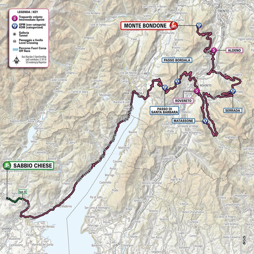
Stage 16: SABBIO CHIESE - MONTE BONDONE 198 Km
Tuesday, May 23
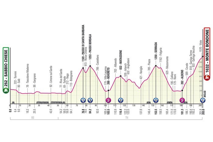
The first 60 kilometres of stage 16 are almost flat, then the climb begins. The remaining 140 kilometres include 5,500 metres of climbing. The final climb, Monte Bondone, is 20.3 kilometres long and has an average gradient of 6.7%.
The race starts along the western shore of Lake Garda. Where the lake ends, riders cross the Sarca River to tackle the short climb to Nago. Just 1.6 kilometers long and with an average gradient of 8.4%, it mainly serves as a reminder that the profile of the route changes. Big time!
The first big climb starts after 5 kilometers in Bolognano. Passo di Santa Barbara starts off tough with a series of hairpin turns and a gradient of up to 11.7%. The climb is 12.3 kilometers long and the average gradient is 8.4%.
A short descent takes riders to Ronzo Chiennis. The Passo di Bordala is essentially a continuation of the Passo di Santa Barbara, only shorter at 3.7 kilometres with an average gradient of 7.1%.
Riders descend the 16-kilometre descent to Rovereto. After crossing the Adige River, the route climbs again. The first 6 kilometres climb at an average gradient of 8.4%, and after a short descent, the remaining climb to Matassone is less demanding. The climb is 11.4 kilometres, and the average gradient is 5.4%.
The descent runs almost parallel to the climb, and riders reach the Adige Valley again to return to the climb on the Cerrada road. The climb is 17.5 kilometers with an average gradient of 5.5%, and the last 10 kilometers to the village climb at an average gradient of 6.6%.
Once again, riders dive into the Adige, this time to follow the river for a while before turning left at Aldeno. This flat section is 10 kilometers long, and then the final climb begins. Monte Bondone. The first 3 kilometers climb at a gradient of 9% before leveling out a bit. The climb is 20.3 kilometers with an average gradient of 6.7%. The steepest sections - up to 15% - appear at an altitude of 12 kilometers.
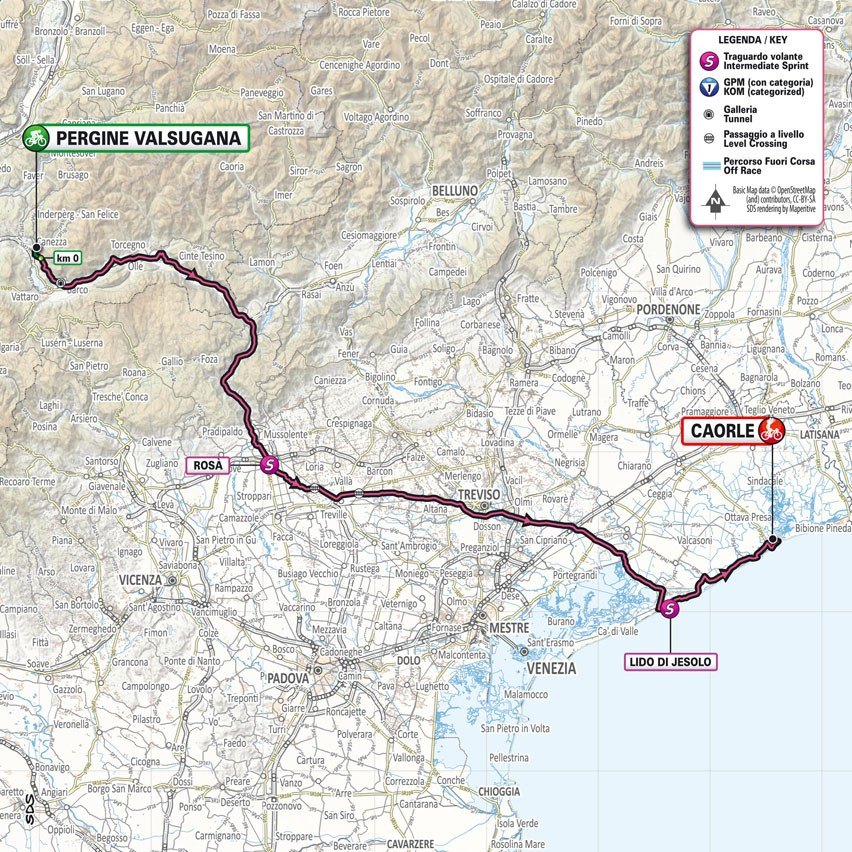
Stage 17: PERGINE VALSUGANA - CAORLE 192 km
Wednesday, May 24
Stage 17 is the flattest of all the Giro d'Italia stages. In fact, the route gradually descends from Pergine Valsugana in the Alps to Caorle on the Adriatic Sea. After 192 kilometers of racing, a sprint is almost certain.
Pergine Valsugana is located at 530 meters above sea level. After a very short climb from the start to 570 meters, the route gradually descends to the coast. The average gradient of the stage is therefore 0.3%.
Riders essentially leave the Alps behind when they cross the Brenta River at Bassano del Grappa to continue across the plains north of Venice. Long, straight roads lead riders to the Adriatic coast, which they reach at Lido di Jesolo. Along sandy beaches, the Giro continues eastward to end with the inevitable mass sprint on the streets of Caorle.
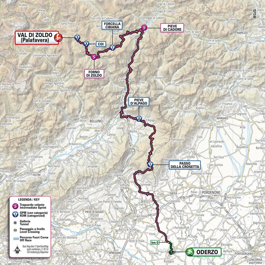
Stage 18: ODERZO - VAL DI ZOLDO 160 Km
Thursday 25th May
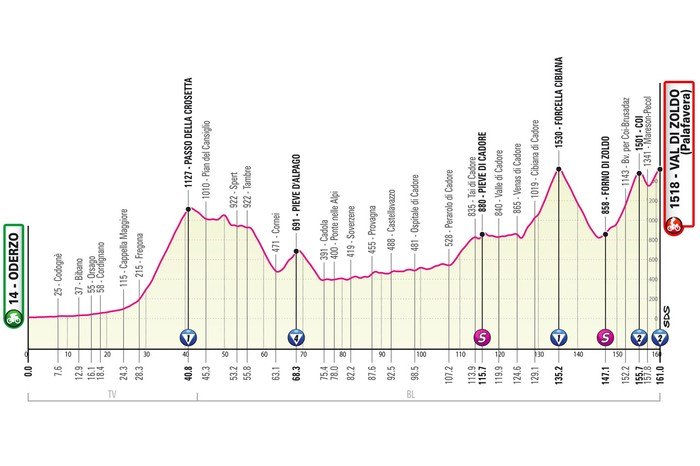
Stage 18 of the Giro opens a trilogy of decisive races with plenty of steep climbs. The 154-kilometre route includes four climbs before a challenging finish in the Zoldo Valley.
The race starts in Oderzo and has a flat phase of 30 kilometers. Then begins the climb to La Crosetta, 13.3 kilometers with an average gradient of 7.2%. After a short undulating section, the route descends to the foot of the Pieve d'Alpago. This is a 4.7-kilometer climb with an average gradient of 6.8%.
In the valley, at Ponte nelle Alpi, the race enters a quiet phase. For a few dozen kilometers, the route climbs a false flat section to Pieve di Cadore, which, at 5.7 kilometers and with an average gradient of 5.2%, serves as a reminder that the finale is about to begin.
The first climb is Passo Cibiana. The climb is 9.6 kilometers long with an average gradient of 7.8% and is completed 23 kilometers before the finish. The first half is descending, and the second half is the final climb, which is of particular interest.
The first 5km of the climb have an average gradient of 9.8% up to Coi, before a sharp descent makes way for a short and explosive climb to Refugio Palafavera.
The Zoldo Alto has not been used as a Giro finish since 2005, when Paolo Savoldelli beat Ivan Basso in a two-man sprint to the summit.
Stage 19: LONGARONE - TRE CIME DI LAVAREDO 182 KM
Friday 26th May
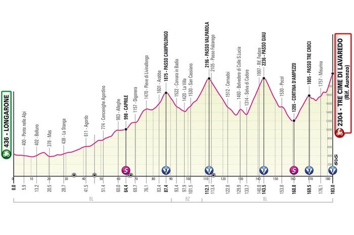
Stage 19 is arguably the toughest route of the entire Giro. The stage includes 2,000 meters of elevation gain in the first half and five giant climbs in the second half. The race is 182 kilometers long and the finish line is located at Tre Cime di Lavaredo.
Stage 19 is the last chance for climbers to advance in the overall standings, as the final two stages are a time trial and a flat race in Rome.
The stage's start and finish have a common history. They haven't been part of the Giro since 2013. But that's really the only thing they have in common. Then the riders rode from Longarone to the finish in Treviso, where Mark Cavendish beat Nacer Bouhanni and Luca Mezgetz.
After the start in Longarone, the riders head into the high mountains. They climb slowly but surely and with very gentle gradients to the foot of the Passo Campolongo. They reach the top of this 4-kilometer climb with a 7% gradient halfway.
The second half of the race is very clear. It’s either uphill or downhill. Riders first climb the Passo Valparola (13.3 kilometres at 5.9%), then the Passo Giau (9.8 kilometres at 9.3%) and the Passo Tre Croci (8.4 kilometres at 7.1%), before a short descent precedes the big finale at the Tre Cime di Lavaredo.
The climb starts with a steep section from Lake Misurina to Lake Antorno, and then continues on the climb itself. Tre Cime di Lavaredo is 9.5 kilometers long and has an average gradient of 7%, while the last 4 kilometers have only double-digit gradients.
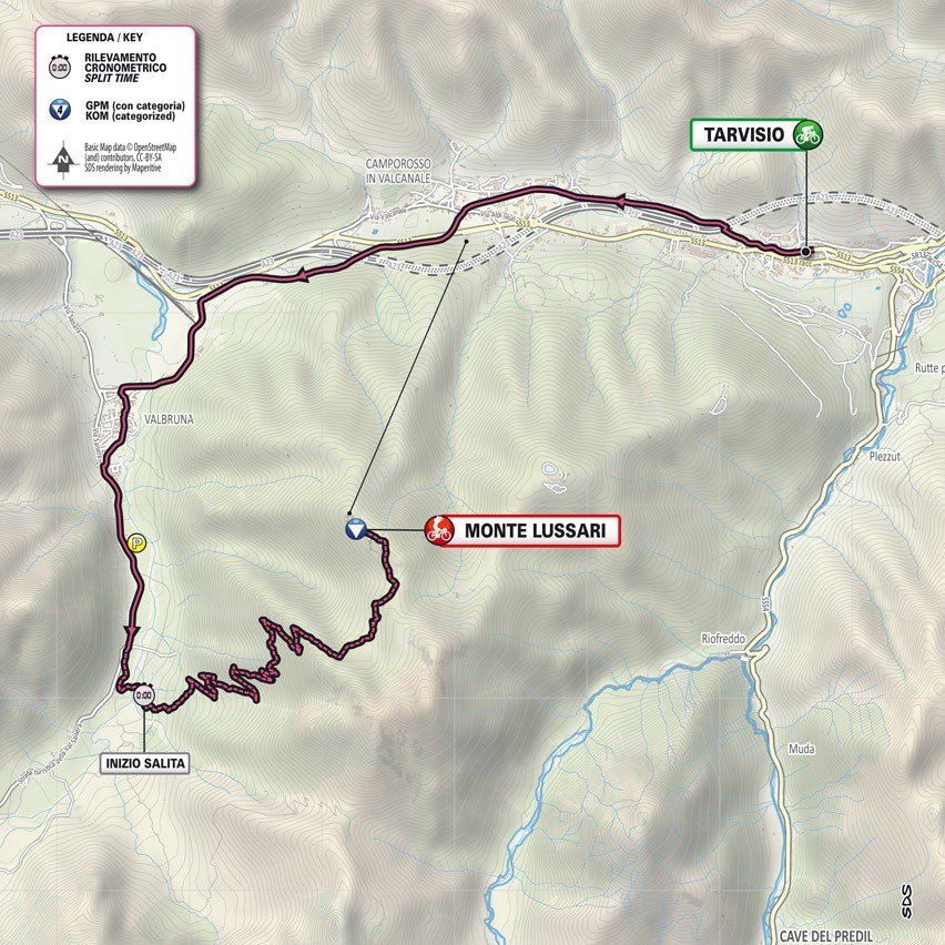
Stage 20: TARVISIO - MONTE LUSSARI 18.6 KM
Saturday 27th May
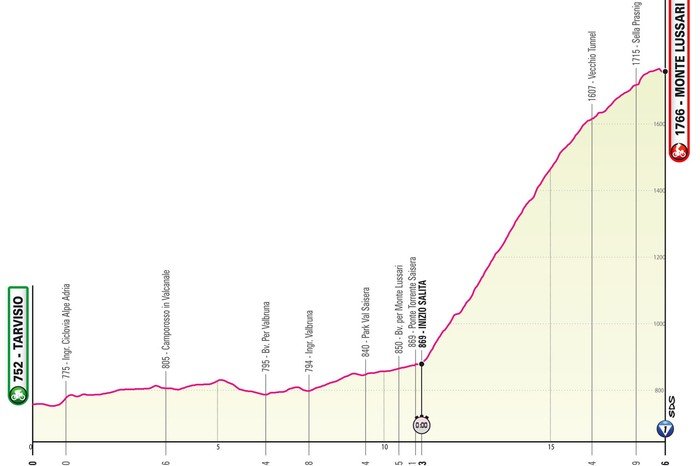
Stage 20 is the last of the three time trial stages of the 2023 race and it is incredibly tough.
The mountain stage from Tarvisio to Monte Lussari includes over 1,050 metres of elevation gain on the huge climb to the monastery at the summit. The first 10 kilometres of the stage are on a flat bike path as you approach Monte Lussari.
However, once the riders start climbing, the flat section is soon forgotten. The first 4.8 kilometers of the climb reach around 15%, which race organizers say is similar to the middle section of the mythical Zoncolan climb.
If they haven't already won a stage in the Dolomites, whoever dons the Maglia Rosa on stage 20 will be looking forward to taking the honour of the stage in that jersey and sealing their overall victory.
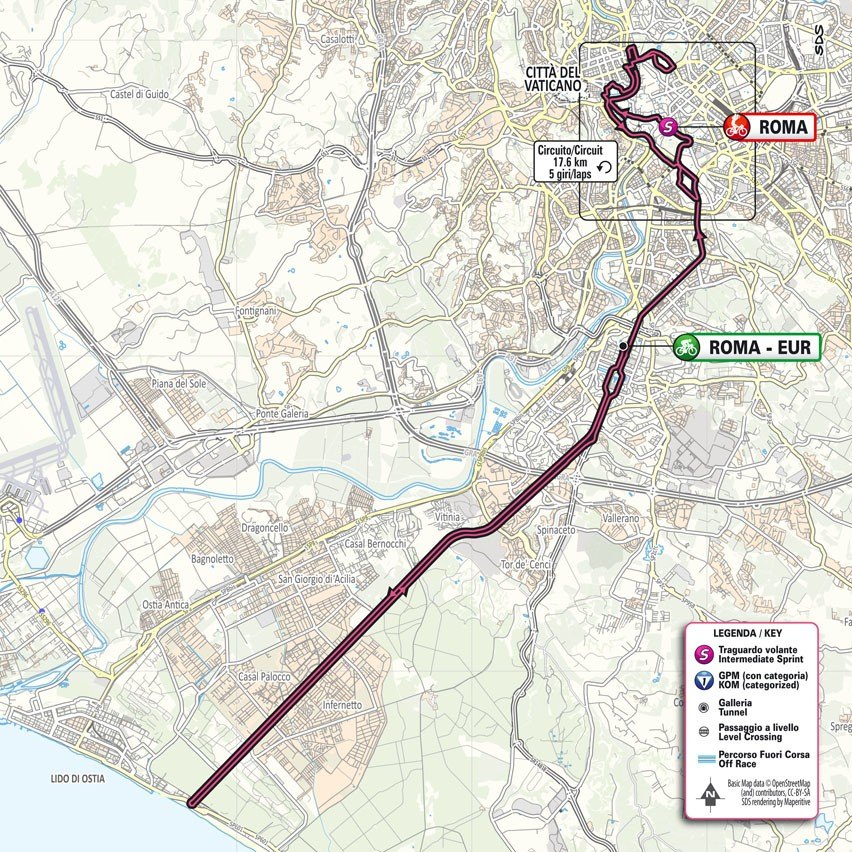
Stage 21: ROME – ROME 115 km
Sunday, May 28
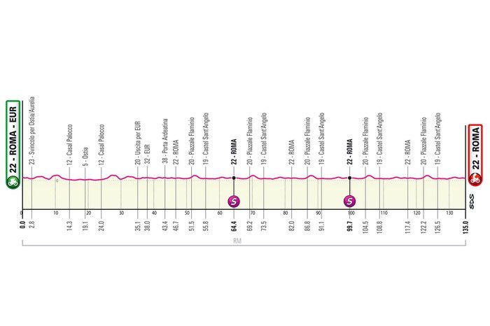
The final stage of the Giro d'Italia is a circuit race in Rome. The route consists of a lap to the coast and back and five almost flat laps of 17.6 kilometres each.
The riders leave the city for one of Rome's beaches, Lido di Castel Fusano. It's 16 kilometers one way and another 16 kilometers back, after which the Giro enters its final lap.
This circuit follows the 2018 Giro d'Italia in Rome, with the addition of a northern loop that runs mostly along the Tiber, but also includes the Villa Borghese park. Another section runs through the old town, along the Circus Maximus to the Colosseum, and the finish is on Via dei Fori Imperiali, halfway between the Colosseum and Piazza Venezia.
The race is a great chance for riders to reward themselves after the huge amount of altitude challenges throughout the Giro, with a total of 51,300 metres of elevation gain throughout the Giro.